
Insurers today need faster, transparent, and more connected ways to understand risks. As digital ecosystems continue to evolve, geospatial data for the insurance industry becomes even more indispensable for accurate underwriting and proactive risk mitigation.
Geospatial data for insurance streamlines every step of decision-making by providing real-time environmental intelligence. By leveraging technologies such as drones and GIS systems, it not only speeds up evaluations but also enhances loss prediction and exposure management.
It is important for insurance companies to invest in GIS software development to enhance underwriting, improve claims efficiency, and operate with stronger real-time risk intelligence.
Here, we’ll discuss the key aspects of geospatial data for insurance. We’ll start with the basics and move on to the various applications, challenges, and workflows that shape its real-world adoption.
What Is Geospatial Data and How Is It Collected?
Geospatial data is specific information tied to a particular spot on Earth. Since each record is tied to a coordinate, analysts can see how things are arranged in a space. They can measure distances or relationships between different features, for example, how far a house is from the road. In the case of custom health insurance software development, tools can be created to indicate a policyholder’s proximity to areas with high disease prevalence.
There are multiple ways in which Geospatial data is collected, the likes of which are mentioned below –
1. Digital and Crowdsourced Data
Digitizing information from paper or older digital maps, gathering user-generated location data from social media platforms, apps, and other platforms, and real-time data generated from sensors and IoT devices
2. Remote Sensing
Examples include – Satellites, drones, aerial photography, LiDAR
3. Ground-based Methods
GPS, specialized equipment to measure distances, angles, and elevations for mapping boundaries and infrastructure
Stats Showing The Importance of GIS Data for Insurance Companies
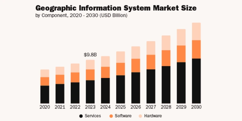
Reference:- grandviewresearch
- There is over $43 billion in uninsured flood risk in the US due to inaccurate data analytics in underwriting.
- Businesses that excel at personalization and leverage advanced technologies like geospatial data are 41% more likely to exceed revenue goals.
- Only 30% insurance industry organizations are utilizing geospatial and location intelligence.
- The global geospatial analytics market size was valued at USD 89.81 billion in 2024. The market is projected to grow from USD 102.45 billion in 2025 to USD 258.06 billion by 2032
- Insurers applying predictive modeling to underwriting and claims can reduce loss ratios by up to 20%.
Applications of Geospatial Data for Insurance Industry
1. Property Insurance
a. Accurate Property Risk Assessment
Instead of studying a broader area, geospatial data for the insurance industry studies the exact risk around a single property. Insurers map a property’s location with environmental details and past events to assess true risk and set accurate premiums.
b. Building Characteristics and Structural Risk
Geospatial data for insurance includes details such as roof condition and material, property size, shape, and construction quality. Insurers collect this data by using high-resolution imagery obtained from devices such as satellites, drones, etc. The images are combined with computer vision and AI.
c. Portfolio-Level Catastrophe Modeling
By leveraging geospatial data analytics in catastrophe modeling; insurers can estimate potential losses from large-scale natural disasters such as earthquakes, floods, etc. They can simulate potential disaster scenarios and project financial losses.
d. Flood Zone Mapping
Through GIS software development, insurers can identify properties within low-lying areas of floodplains with precision. The software can show historical flood data and the proximity of a property near water bodies. In the event of a flood, real-time flood maps can help verify if the property was in the impact zone.
e. Wildfire Hazard Modeling
GIS data for insurance companies is crucial for modeling wildfire risk as it helps identify properties’ proximity to forests, historical fire data, and vegetation density. This can help insurers identify high-risk properties that require fire-resistant measures.
f. Storm Surge and Wind Vulnerability
Geospatial data for insurance, combined with real-time weather feeds and historical data; helps find out the vulnerability of properties to high winds and storm surges.
g. Crime Zone Analysis
Geospatial data for the insurance industry is crucial as it helps map crime hotspots around all kinds of properties. More specifically, insurers can assess vandalism or theft risk and price policies more accurately.
2. Auto and Fleet Insurance
a. Real-Time Driving Behavior Analysis
In auto and fleet insurance, geospatial data like – speed, GPS location, acceleration, braking patterns, and route history is collected via in-vehicle telematics, IoT sensors, and mobile apps; to analyze real-time driving behavior for risk assessment.
b. Risk Mapping of Transportation Routes
Insurers can invest in GIS software development; and create tools that generate detailed maps of hazardous locations that can be harmful for vehicles. These help identify potential hazards along transportation routes. By layering aspects like weather patterns; past accidents, and crime rates, insurers can use geospatial data for insurance industry effectively, and see danger spots and set premiums.
c. Accident Reconstruction & Claims Validation
Geospatial data helps in claims validation by accurately providing an objective, location-based view of the incident. Using drone data, satellite imagery, and historical environmental conditions at the exact time and location of an accident, insurers can verify claims against real-world data.
d. Accident Hotspots
Geospatial analysis identifies accident hotspots or high-risk zones where accident risk is higher than usual. By analyzing spatial patterns of historical accident data; insurers and urban planners can understand contributing factors and moreover, inform risk pricing.
e. Road Geometry and Traffic Density
In auto and fleet insurance, where the road geometry offers data points such as road design, curves, slopes, and intersections, traffic density measures vehicle flow and congestion. Insurers use this data to assess accident risks and set accurate premiums.
f. Route-based Risk Scoring
Route-based scoring uses – maps, traffic, and accident data to rate how risky a road is. Insurers can use this rating or score to set premiums. Additionally; insurers can also use this rating to guide drivers on safer routes and prevent fraudulent claims.
3. Agricultural and Disaster Coverage
a. Crop Health Monitoring
Insurers leverage geospatial data to enhance risk assessment and underwriting. Using this data; they can track crop conditions using vegetation indices and satellite imagery to detect disease, stress, and pest outbreaks before they escalate.
b. Parametric Claims Using Geospatial Signals
Automated payouts for parametric insurance can be triggered when events like temperature, wind speed, and rainfall exceed predefined thresholds. This process relies on geospatial data analytics.
c. Disaster Risk Modeling
Insurers can use geospatial data for insurance to predict potential losses from hurricanes, wildfires, floods, and other disasters. In fact, they can analyze past events, property exposure, and topography to predict such events.
d. Soil Moisture, Crop Health
Soil moisture levels and crop growth are useful geospatial data for the insurance industry. Using these insights, insurers can make better coverage decisions and support farmers with actionable risk management information.
e. Drought & Rainfall Patterns
Analyzing long-term rainfall and drought trends allows insurers to identify water-stressed areas, adjust crop coverage, and plan parametric triggers. Hence, geospatial data for insurance industry can help predict losses caused by climate change.
f. Disaster-prone Regions for Parametric Insurance
Mapping areas prone to floods, cyclones, or storms; helps insurers design parametric products with accurate thresholds. Geospatial data for insurance industry ensures faster payouts; reduces disputes, and strengthens resilience in high-risk regions.
GIS Data for Insurance Companies – How It’s Useful
1. Enhancing Underwriting and Risk Selection
Instead of performing generalized risk assessments; advanced technologies such as GIS data analysis and AI in Underwriting, perform highly specific, address-level analysis. Underwriters can combine various data points; like how near a property is to wildfire zones, earthquake fault lines, floodplains, etc.
2. Catastrophe Modeling and Risk Prediction
GIS (Geographic Information System) data maps hazards, infrastructure, population, and historical disaster patterns to model potential catastrophes. Insurers can use this data to set accurate premiums once they predict losses. They can improve underwriting and reduce financial exposure.
3. Improving Claims Management and Fraud Detection
GIS speeds up claims processing by using real-time satellite and drone imagery combined with AI in claim management. These assess damage without the need for physical inspections. GIS data also helps flag anomalies and suspicious patterns by cross-referencing a claim’s location with environmental conditions and other historical claim data.
4. Portfolio Risk Management
Using GIS data, insurers can clearly see the geographic distribution of their policies. This lets them identify areas with higher risk. With this; they can manage their portfolio to avoid excessive losses from a single catastrophic event.
5. Real-Time Monitoring and Risk Alerts
GIS lets insurers monitor hazards; storms, floods, or accidents in real-time; so that they can assess exposure quickly. This helps them manage claims while reducing potential losses.
6. Supporting Usage-Based and Telematics Insurance
By combining GIS with vehicle tracking and telematics, insurers can track where the vehicle is traveling and how it is driven. This can help insurers monitor the actual risk, based on which they can adjust the premium depending on the driver’s actual behavior.
7. Fraud Prevention and Loss Control
At every stage GIS checks if a claim matches what actually happened. Geospatial data for insurance industry analyzes factors – such as location, weather, and historical events. It flags anything suspicious, which is important to stop false claims. After these checks, insurers can reduce fraud and avoid big losses that come from paying claims that were never real, protecting their overall financial stability.
8. Strategic Planning and Product Development
By taking a purview of the GIS data, and seeing where risks are and where customers are located; insurers can design the right insurance products, and set sensible coverage. This can help them stay competitive and avoid financial losses; offer policies that fit customer needs.

Integration with AI and Predictive Models
1. How AI Enhances Geospatial Datasets?
The geospatial data for the insurance industry is collected in raw form. AI helps clean, and organize this raw location data; enabling insurers to gain clearer insights. Furthermore it also automates tasks; such as automatically identifying hidden risk patterns, detecting damaged properties, and updating maps.
2. Machine Learning for Risk Prediction
Machine learning, when combined with geospatial data analytics, helps predict future risks by analyzing – weather patterns, land conditions, and claim histories. Using these insights, insurers can set appropriate premiums. They can add specific coverage limits, exclusions, or safety requirements.
3. Combining Policyholder Data with Environmental Models
Insurers blend customer details; like driving habits, property condition, crop type, etc, with environmental models such as weather patterns, flood zones, crime activity, etc. The datasets can be combined to ascertain exact risks, based on which fair premiums can be offered.
Benefits of Geospatial-Driven Underwriting
1. Improved Risk Segmentation
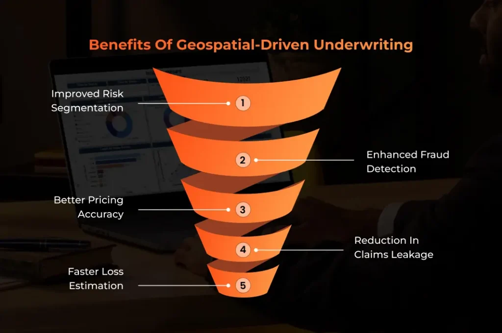
In underwriting, geospatial data for insurance industry enables hyper-local risk profiling. This implies that it assesses risk location by location, rather than just by broad areas such as pin code or district. Using data such as distance from rivers, flood history, wildfire exposure, etc., insurers can understand the precise risk around each property. They can leverage this data to sort customers into accurate risk categories, such as high or low risk, and set better pricing, premiums, etc.
2. Better Pricing Accuracy
With the help of geospatial data analytics and enhanced risk segmentation as shown above, insurers can set up more accurate and fair pricing. Geospatial data for the insurance industry gives insurers a broader picture of the whole area; as such, instead of using generalized rates, they can tailor premiums based on a customer’s risk profile. This ensures that customers pay the right price for their own risk level; customers whose risk profile is marked safe don’t end up paying extra.
3. Faster Loss Estimation
Insurers use tools such as real-time maps, satellite images, and drone footage to collect, process and analyze geospatial data for insurance. This helps them understand how exposed it is to hazards and how a disaster has impacted the area. By visualizing risks and damages on a map; insurers can make faster and more accurate pricing and claim decisions.
4. Enhanced Fraud Detection
By investing in insurance fraud detection automation development, you can have tools that help cross-check a claim’s validity against real-time environmental conditions and historical data. Geospatial insights verify whether the reported event actually occurred at the place and time. For example, accident hotspots, exact claim coordinates can be used to ascertain if the vehicle for which the insurance is claimed was at the claimed accident spots or if there are any instances of staged or duplicate accidents.
5. Reduction in Claims Leakage
Claims leakage occurs when the amount paid on a claim exceeds the original estimate or reserve. Geospatial-driven underwriting reduces claims leakage by showing the actual risk of a location before issuing the policy. It uses maps, satellite images, and hazard layers to reveal accident hotspots, flood zones, and past events. With this clarity; insurers can reject suspicious proposals, prevent future claim surprises that inflate payouts, and set correct reserves.
Best Geospatial Data Solutions for Insurance Risk Management
1. GIA Map

GIA map is one of the best geospatial data solutions for insurance risk management. It helps home, auto, and commercial property insurers measure and manage exposure using geospatial intelligence. It helps boost underwriting and rating results through address-level vulnerability scoring and identifies the most desirable growth areas to launch new products.
2. Birdi.io

Birdi.io is another great geospatial data solution for insurance risk management that compares pre- and post-property conditions. It even monitors changes over time and helps insurers make accurate claim decisions. With its help, insurers can conduct remote, location-based property assessment of claims and determine risk concentration in the portfolio.
3. BigGeo
BigGeo is considered one of the best geospatial data solutions for insurance risk management. The platform helps insurance adjusters streamline the claim process by allowing them to assess damage and determine liability quickly. It offers real-time access to geospatial data. It lets companies leverage geospatial intelligence to detect and prevent insurance fraud by cross-referencing claims data with location-specific information.
4. Ecopia AI

Ecopia AI uses a dedicated geocoding engine powered by machine learning; in order to match each address to its exact building at scale. This accuracy helps insurers make better underwriting and risk-selection decisions because every location-based assessment starts with precise, trustworthy data.
5. Nearmap

Nearmap’s Betterview is a risk management and property intelligence platform that features workflow tools like automated flagging and a user-friendly interface. With it; users access over 2500 geospatial data points per property; including AI detections and third-party hazard related data.
Challenges in Geospatial Data Implementation
1. Data Privacy & Regulatory Constraints (GDPR, CCPA)
Geospatial data contains sensitive location information; it is important for insurers to follow strict laws like GDPR and CCPA. These regulations require consent, secure storage, and limits on how data is used. Failure to comply can lead to penalties and comes with legal risks.
2. High Volume and Complexity of Data Processing
Geospatial systems process large amounts of datasets; these are related to satellite imagery, drone feeds, traffic patterns, weather layers, and more. Handling this volume requires powerful computing; apart from structured pipelines, and specialized tools. Without the right infrastructure; insurers struggle to clean, analyze, and interpret data to support real-time decisions.
3. Integration Issues with Legacy Systems
Older insurance systems are incapable of handling complex geospatial files, interactive maps, or real-time data streams. Connecting new GIS tools with outdated databases causes delays, errors, and data mismatches. Insurers must upgrade or modernize their architecture to use geospatial intelligence effectively across underwriting and claims.
4. Need for Advanced Analytics and GIS Expertise
Geospatial data requires professionals who understand mapping, data science, hazard modeling, and GIS tools. Many insurance teams lack this skill set. Without trained analysts, companies cannot fully interpret spatial relationships or convert raw coordinates and imagery into meaningful risk insights or operational decisions.
5. Cost of High-resolution Datasets and Infrastructure
High-quality satellite images, aerial surveys, processing servers, storage, and GIS platforms can be expensive. Insurers must invest in both technology and ongoing data subscriptions. For many organizations; the cost becomes a barrier, especially when scaling geospatial capabilities across multiple business functions.

Future Outlook
1. Drones Conducting Autonomous Property Inspections
In the future; drones will move beyond manual operation to conduct fully autonomous inspections for claims management and risk assessments. Equipped with LiDAR; high-resolution cameras, and thermal cameras, drones will capture detailed, time-stamped data for making faster underwriting decisions.
2. AI-powered Catastrophic Risk Simulation Models
AI and machine learning models will power advanced models to simulate catastrophic events. Using these scenarios; insurers will be able to develop better risk management strategies, advise clients on preventive measures, and adjust coverage limits.
3. Digital Twins of Cities and Properties for Real-time Risk Assessment
IoT sensors will provide a constant stream of data from buildings, infrastructure, and even entire urban environments to their digital twins. These digital twins will help insurers and adjusters compare the physical property’s condition with its digital twin. Insurers will even be able to detect potential frauds.
4. Hyper-local Dynamic Insurance Pricing
Geospatial data will facilitate a shift from broad, demographic-based pricing to hyper-local, dynamic models that will tailor premiums to individual risk profiles in real time. Insurers will be able to pinpoint risk at the individual property level. The approach will also ensure fairer premiums and proactive risk mitigation.
5. Parametric Insurance Powered by Automated Geospatial Triggers
Parametric insurance, which pays out automatically based on a predefined trigger event (e.g., an earthquake of a certain magnitude, specific wind speeds, or a flood reaching a certain height), will be revolutionized by automated geospatial triggers.

Why Choose A3Logics for Geospatial Data Analytics Solutions?
i. Strong Expertise in Insurance Technology
A3Logics is a seasoned Insurance Software Development Company with proven experience in applying geospatial intelligence to underwriting and claims. Our solutions help insurers understand true risk, lower potential losses, and make faster, more reliable business decisions.
ii. AI-Driven Geospatial Intelligence
By combining AI with geospatial inputs such as satellite imagery and hazard maps, we help insurers validate claims quickly, identify potential fraud, and assess exposure with clarity. This leads to faster claim resolution and stronger loss control.
iii. Scalable and Reliable Geo Platforms
Through our software development services, we deliver scalable geospatial platforms that integrate smoothly with existing insurance systems. They are secure, efficient, and easy to adopt, enabling insurers to modernize operations without disrupting ongoing business.
Final Thought
In a data-driven world where accuracy defines success in insurance, geospatial data becomes a game-changer for risk evaluation and decision-making. It not only sharpens underwriting but also accelerates claims. This growing impact makes it essential for insurers to invest in modern GIS technology so they can control losses and manage exposures while at the same time improving outcomes for customers.
In this overview, we have discussed some of the most essential aspects of geospatial innovation in insurance. If you wish to explore these capabilities further, you can partner with A3Logics and bring your data strategies to life with tailored, enterprise-grade solutions.